
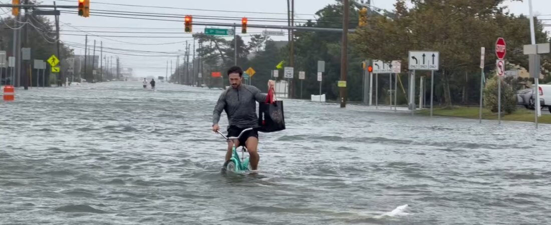
Photo credit: Social Media / X
A slow-moving storm has pushed seawater into New Jersey’s shore towns again and again since Friday. Eight counties are under a state of emergency, and officials warned the flooding wasn’t over as of Sunday night.
New Jersey Hit by Powerful Nor’easter
A powerful nor’easter has been battering the New Jersey coast since Friday, September 25. Strong winds, heavy rain and rising tides have flooded streets, homes and businesses in shore towns from Monmouth County down to Cape May.
On Friday, Governor Mikie Sherrill declared a state of emergency for eight counties expected to be hit hardest.
By Sunday, residents of coastal communities were slogging through floodwaters for a second day, according to the Associated Press.
The storm has also turned deadly elsewhere in the region. In New York City, a city housing authority worker was killed on Saturday when a tree fell, AP reported.
Floodwaters Return With Each High Tide
What makes this storm so hard to deal with is that the flooding doesn’t come once and go away. It comes back.
Twice a day, the tide rises. With the storm’s winds pushing ocean water toward the coast, each high tide has brought a new wave of flooding into low-lying streets.
In the beach town of Sea Bright, resident Caroline Virenius described it simply: “It’s not like a one-time occurrence. It’s getting wet again and again.” Her garage filled with about a foot of water, according to AP.
That means people can’t simply wait for the water to drain and start cleaning up. Many cleared out after one high tide, only to watch the water return with the next.
Sea Bright and Other Coastal Towns Under Water
Sea Bright is especially exposed. The small borough sits on a narrow strip of land, with the Atlantic Ocean on one side and the Shrewsbury River on the other. When wind and tide push water in from both directions, the town floods from the front and the back.
Before the storm, Sea Bright’s mayor, Brian Kelly, warned it could be “closer to an Irene-scale flooding event,” referring to the major storm of 2011, according to NBC News. Over the weekend, emergency crews carried out water rescues in the town, including a woman and her dog whose car became trapped in floodwaters, AP reported.
Other shore towns were hit too:
- Manasquan and Point Pleasant issued voluntary evacuations for people in low-lying homes, as cars sat half-underwater in flooded streets.
- In Surf City, water rose inside a marina, and customers reported boats and Jet Skis missing or blown from their lifts, AP reported.
- In the West Atlantic City section of Egg Harbor Township, floodwater 2 to 3 feet deep filled first-floor rooms at two motels, and crews rescued nine adults and a dog, 6abc reported, according to AccuWeather.
- Brigantine’s mayor, Vince Sera, called it the worst tidal flooding the town had seen since Superstorm Sandy.
Not everyone saw it that way. “I think it’s a little worse flooding than Irene in 2011. Nowhere near Sandy,” Sea Bright resident Joe Zolik told CBS News New York.
Wind, Rain and Beach Damage
At a storm briefing on Sunday morning, Governor Sherrill gave the state’s first official picture of the damage, according to News 12 New Jersey:
- Severe dune loss in Brigantine and Atlantic City. Dunes are the sand hills that protect beach towns from the ocean.
- A wind gust of 74 mph recorded in Surf City.
- About 3 inches of rain in some coastal communities as of Sunday morning. By Sunday night, AP reported more than 4 inches since Friday in some parts of the state, with residents describing flooding not seen in close to a decade.
Other high gusts in Ocean County, according to the National Weather Service, included 70 mph at Island Beach State Park, 69 mph in Harvey Cedars and 67 mph in Ship Bottom.
How High the Water Was Forecast to Rise
It’s worth being clear about what these numbers are. The figures below are the National Weather Service’s forecasts in its official warnings, meaning how deep it expected flooding to get above ground level. Measured peak water levels from New Jersey’s tide gauges had not been published as of Sunday night.
The Weather Service’s Mount Holly office, which covers most of the Jersey Shore, issued coastal flood warnings through the weekend:
- Cumberland, Atlantic and Cape May counties: a warning issued Saturday morning called for 2 to 3 feet of water above ground level in low-lying areas near shorelines and tidal waterways, enough, it said, to possibly cause structural damage.
- Eastern Monmouth County: warnings called for 1 to 2 feet, with many roads impassable.
- Coastal Ocean County: a warning issued Sunday called for up to 1 foot, lasting until 2 p.m. Monday.
Offshore, waves broke at up to 10 to 12 feet in the surf zone along parts of the Jersey Shore on Saturday, according to the Weather Service’s high surf warnings.
Why This Storm Is Causing Such Bad Flooding
A nor’easter is a large storm that moves up the East Coast, with strong winds blowing in from the northeast, off the ocean.
This one has combined several problems at once:
- Days of wind pushing water toward land. Onshore winds had been driving water toward the coast for days, even before the storm itself arrived.
- Repeated high tides. Every high tide raises the water on top of what the wind has already piled up.
- Heavy rain. Rainwater adds to the flooding, especially where it can’t drain into the already-high sea.
- Slow movement. The storm lingered for days instead of passing through quickly. On Sunday, it was expected to loop around the area for roughly another 24 hours, AP reported, citing Weather Service forecaster Bob Oravec.
- Low-lying land. Towns like Sea Bright sit barely above sea level, and the back bays and rivers behind them fill up and spill over.
Put together, the ocean doesn’t need to crash over the beach. It simply rises into the streets.
Power Outages and Disruptions Across the Northeast
The storm’s effects reached far beyond New Jersey.
- Power: about 136,000 homes and businesses were without power across five Northeast states on Sunday morning, falling to about 110,000 by early afternoon, according to PowerOutage.us figures reported by Yahoo News. New Jersey accounted for about 40,100 of those, led by Ocean County (about 13,100) and Monmouth County (about 10,500). Governor Sherrill said nearly 180,000 New Jersey customers had already had power restored by Sunday morning. The two numbers measure different things: 180,000 is the total restored since the storm began, while 40,100 is how many were still waiting at one moment on Sunday afternoon.
- Flights: more than 250 flights had been cancelled at Boston’s Logan International Airport by late Sunday morning, according to AP, with more delays up and down the coast.
- Trees: strong winds toppled trees on New York’s Long Island and in New York City, damaging homes and bringing down power lines.
One reason for the tree damage: this is an early-season storm, and trees still have their leaves. Leaves catch more wind, which makes branches more likely to snap onto roads and power lines.
New Jersey Declares a State of Emergency
Governor Sherrill signed Executive Order No. 25, putting eight counties under a state of emergency from 5 p.m. on Friday, September 25, according to the New Jersey Governor’s Office.
The counties are Atlantic, Burlington, Cape May, Cumberland, Middlesex, Monmouth, Ocean and Salem.
The order activated the State Emergency Operations Center, bringing the New Jersey State Police, the Department of Environmental Protection, the Department of Transportation and county emergency offices together to coordinate the response.
“I urge all New Jerseyans to take this storm seriously, stay safe and be prepared,” Sherrill said.
What Officials Were Warning as of Sunday Night
On Sunday, the Weather Service said the storm was slowly weakening, but that tidal flooding would continue through the high-tide cycles into Sunday night, according to AP.
Governor Sherrill was blunter: “To be clear, we’re not out of the woods yet.” She said the Monday morning high tide, around 9 a.m., was a particular concern for more coastal flooding. Local officials in New Jersey also warned that Monday’s later high tide could bring more flooding, AP reported.
In Ocean County, the coastal flood warning runs until 2 p.m. Monday, and the Weather Service said flooding in the back bays, the shallow waters behind the barrier islands, may last beyond Monday afternoon. It warned that numerous roads could be closed, and that low-lying homes, businesses and some critical infrastructure could be flooded.
Residents can check live water levels for their local tide gauge through the National Water Prediction Service, and road closures on 511NJ.
What Residents Are Being Told
State and local officials have repeated the same basic safety advice:
- Never drive through flooded roads. “I want to repeat: do not drive in closed or flooded roadways,” Sherrill said on Sunday. The water may be deeper than it looks.
- Stay off the roads if possible.
- Stay away from beaches and the surf, where rip currents and breaking waves are dangerous.
- Charge your phone, and keep food and water on hand in case of power cuts.
- Secure loose outdoor items that strong winds could throw around.
- Follow local emergency instructions, including evacuation orders.
What Happens Next
The storm is expected to weaken and move away, but the water will take longer to leave.
Officials will be watching:
- Monday’s high tides, especially the one around 9 a.m.
- Back-bay flooding, which may last beyond Monday afternoon
- Power restoration across the region
- Measured water levels, once tide-gauge data is published
- Damage assessments, including how much beach and dune was lost in Brigantine, Atlantic City and elsewhere
Conclusion
This nor’easter was not one dramatic moment. It was days of wind pushing the sea toward land, with each high tide bringing the water back into the same streets. The real measure of the damage, from lost dunes to flooded homes, will only become clear once the water goes down.
By The Lion Capital Editorial Team | September 2026