
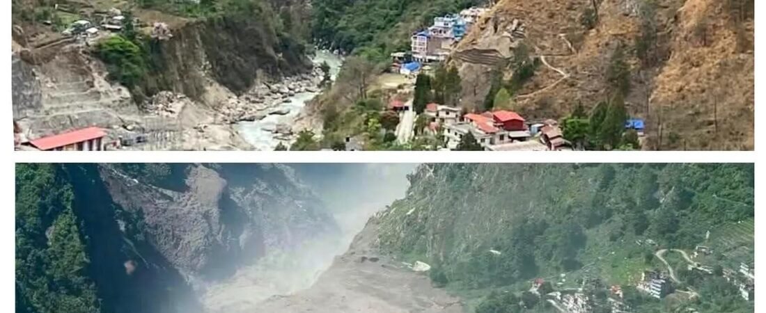
Photo Credit: Unknown
A devastating flash flood struck Nepal’s Himalayan border region, destroying homes, roads and bridges and leaving hundreds dead or missing as rescue teams search for survivors.
INTRODUCTION
On August 26, 2026, a high-altitude ice-and-rock collapse unleashed a catastrophic surge through Nepal’s Himalayan border region. The wall of water, ice, and debris tore down the Lhende Khola River and into the Bhote Koshi–Trishuli system, destroying settlements, roads, bridges, and hydropower infrastructure in minutes. As recovery operations proceeded, Nepal Police reported 469 confirmed dead with approximately 977 listed missing in Nepal; the Chinese side reported 558 people missing on their territory. All figures remained provisional and expected to rise as search teams continued working through debris. This explainer traces what happened, why it happened, and the reconstruction challenges ahead.
PART 1: WHAT HAPPENED
On the morning of August 26, 2026, a seismic signal was recorded near the Tibetan border at approximately 8:37 a.m., followed minutes later by a catastrophic surge entering Nepal’s Rasuwa district around 9:00–9:15 a.m. The wave tore down the Lhende Khola River and into the Bhote Koshi and Trishuli River system, devastating communities including Timure and Syabrubesi as it swept south into Nepal.
Water levels in the Trishuli rose approximately 9 meters (30 feet) in roughly 30 minutes—a surge that submerged everything in its path. Terrifying images captured residents trapped on rooftops and balconies as waters and debris swept away homes, vehicles, and infrastructure. Border monitoring stations near the Nepal-China crossing were destroyed in the initial torrent, eliminating instruments that might have provided early notice. However, SMS early-warning alerts were issued downstream after the surge was already moving, giving some lower-basin communities minutes of notice before the flood arrived.
Nepal Police reported 469 confirmed dead, with approximately 977 listed missing in Nepal. The Chinese side reported 558 people missing on their territory, including 260 foreign nationals. These figures remained provisional and continued to evolve as recovery operations proceeded.
The disaster struck when the trans-Himalayan transport corridor was active with tourists, pilgrims traveling to Mount Kailash, and workers maintaining critical infrastructure. Indian pilgrims undertaking religious journeys, Chinese workers at hydropower facilities, and nationals from the United States, United Kingdom, and Australia were among those swept away. The U.S. State Department, led by Secretary of State Marco Rubio, issued statements of solidarity and mobilized diplomatic resources.
Hospitals in the affected regions were themselves damaged, creating an immediate medical crisis. Survivors faced trauma and displacement in remote valleys cut off from assistance. The Nepal Army deployed helicopter rescue operations, though most stranded settlements could only be accessed by air in the critical hours following the flood.
PART 2: WHY IT HAPPENED
Unlike monsoon floods that regularly strike Nepal during rainy season, this disaster arrived with no significant rainfall. Nepal’s Department of Hydrology and Meteorology confirmed clear skies in Rasuwa district immediately before the flood—the first critical clue pointing not to rain, but to high-altitude mass movement.
Satellite imagery examined by scientists at the International Centre for Integrated Mountain Development (ICIMOD) revealed the trigger: a large mass of ice and rock had broken free from a glacier in the Lhende Khola catchment, approximately 20 kilometers upstream of the Rasuwagadhi border crossing.
Scientists described an ice-and-rock collapse that briefly dammed the Lhende Khola. Water piled up behind that debris barrier and then released in a sudden surge—a related glacial hazard, but not a confirmed outburst from a mapped glacial lake. The mechanism differs from a classic GLOF (glacial lake outburst flood), which occurs when water drains from a pre-existing glacial lake after failure of a natural dam. In this case, the collapse itself created the temporary barrier and subsequent release.
A magnitude 4.4 earthquake was detected in Tibetan territory around the time of the event. The U.S. Geological Survey later attributed this seismic signal to the collapse and debris flow itself rather than to tectonic activity triggering the flood. Scientists emphasized that satellite imagery, hydrological data, and meteorological records pointed to the glacier failure as the primary trigger.
However, the exact chain of events remained under investigation by scientists on both sides of the Nepal-China border. The ice-and-rock avalanche mechanism is the leading preliminary assessment, not a concluded forensic finding.
PART 3: THE DAMAGE
The destruction was catastrophic and transboundary. The Miteripul (Sino-Nepal Friendship Bridge), reconstructed after a similar flood destroyed it in July 2025, was demolished again. This is Nepal’s primary overland trade route to China, handling billions of rupees in annual commerce.
Gyirong Port on the Chinese side—reported to process nearly one-third of Nepal-China commercial traffic in 2024—was severely damaged. According to aerial imagery released by the Chinese military, the customs office, police station, and most facilities were swept away or buried under meters of mud and debris. The Rasuwa Port facility on the Nepal side suffered similar damage.
Hydropower infrastructure bore severe economic impact. Nepal’s energy ministry reported that the flood damaged multiple projects, with estimates ranging from 354 to 748 megawatts depending on which facilities were included. The Rasuwagadhi hydropower project—a 111-megawatt facility that began operations on December 31, 2024—operated for only six months and eight days before this catastrophic flood struck it.
This repetition is critical context: July 2025 saw similar flooding in this same corridor, with reported deaths ranging from nine to higher estimates. That flood destroyed the Friendship Bridge and damaged Rasuwagadhi. Now, fourteen months later, the same infrastructure was destroyed again. Two major events in fourteen months have demolished the same facilities twice, creating immediate questions about reconstruction strategy and whether this location can support permanent infrastructure.
Roads and highways were washed away in multiple locations. Several key telemetry stations on the Bhote Koshi–Trishuli system were completely destroyed. Entire villages lost homes, schools, and community infrastructure. The damage to cross-border infrastructure was enormous, requiring complete rebuilding of bridges and ports before trade could resume.
PART 4: RECONSTRUCTION & UNRESOLVED QUESTIONS
The Hindu Kush-Himalayan region is warming faster than the global average. Over the past decade, temperatures in the Himalayan high country have risen noticeably, destabilizing glaciers and increasing the likelihood of catastrophic mass movements: ice avalanches, rockfalls, and debris-dam outbursts. This context matters for understanding whether similar events may recur.
Immediate recovery priorities are clear: continuing search operations, treating injured survivors, and establishing safe evacuation routes for stranded communities. The Nepal Army deployed helicopter operations, and medical facilities damaged by the flood are treating patients despite constraints.
However, the critical unresolved question is this: the Rasuwagadhi hydropower project was rebuilt and operational for six months before this catastrophic flood destroyed it again. The Friendship Bridge was rebuilt after July 2025 and destroyed again in August 2026. Nepal and China must now decide whether to rebuild this infrastructure in the same locations, strengthen it to withstand future glacial hazards, or relocate it entirely.
Scientists are calling for expanded early warning systems that can detect unstable glaciers before collapse. Nepal and China formalized information-sharing agreements after the July 2025 flood, but this second event revealed critical gaps in detection and response capability. SMS alerts were issued downstream only after the surge had begun—not enough time for upstream communities.
The reconstruction decisions made in the coming weeks will determine whether the Bhote Koshi corridor becomes more resilient or remains vulnerable to repeat damage. Those decisions require coordination between Nepal and China, sustained investment in monitoring infrastructure, and honest assessment of whether some projects can safely operate in hazard zones that may be increasingly active.
CONCLUSION
The Bhote Koshi flood killed at least 469 people confirmed dead, with 977 listed missing in Nepal and 558 on the Chinese side. It was triggered by a high-altitude ice-and-rock collapse that dammed and then released the Lhende Khola—a glacial hazard distinct from rainfall-driven flooding.
That it occurred just fourteen months after a similar event that destroyed the same bridge and hydropower facility is not incidental. It is a warning that the infrastructure connecting Nepal to China, and the communities that depend on it, face accelerating risk from glacial hazards in a warming climate.
Recovery operations are underway. Reconstruction will follow. But the most important work—deciding whether and how to rebuild in hazard zones—has not yet begun. The answer to that question will determine whether the next fourteen months bring another catastrophe or a genuine step toward safety.
By The Lion Capital Editorial Team | August 2026